I recently created a separate WordPress blog to host my landscape architecture graduate student portfolio, where I have also started making the odd blog post. I anticipate that, if I get back to writing proper, dedicated Nova Scotia landscape-based blog posts, I will cross-post them between the two blogs. In the meantime, you can find me at Bluenose Gardener. Yes, my landscape blog and my personal blog have their titles and their addresses reversed! I did not plan far enough in advance when I first created Bluenose Garden.
In addition, I can occasionally be found at my Tumblr (typically pictures I’ve taken that you may also see at my personal website) and at Twitter, which I monitor and post to intermittently.
It’s been a very long haul but I am finally finished my Master of Landscape Architecture degree at the University of Guelph. I entered the landscape architecture field in large part through my love of history, and I hope I will be able to find a job that allows me to exercise my interests towards making a meaningful contribution to the cultural landscapes of Nova Scotia/the Atlantic Provinces (my heart is on the East Coast). At the very least, I hope to blog here a bit more frequently now that the weight of always having an unfinished thesis has been lifted off my shoulders. For reasons almost exclusively rooted in self-promotion (not something I do well, so I’ve decided to seize the moment while it lasts), here is the abstract for my recently completed thesis:
Meaning and Imagined Memories: Exploring Literary Landscape Theory Through the Aesthetics of Lucy Maud Montgomery
This thesis explores the theory of literary landscapes. The research is composed primarily of an interdisciplinary literature review that draws on landscape architectural theory, tourism studies, literary criticism, and landscape history and cultural geography, as well as archival research and site visits. It positions literary landscapes in relation to the landscape meaning discourse, and argues that they are an essentially experiential way of perceiving landscape through the use of “imagined memories” by the literary visitor. Using the example of L.M. Montgomery, the research explores how understanding an author’s landscape aesthetic can reveal past and present meaning in the landscape, and how this aesthetic—understood formally, thematically, and as embodied experience—allows us to understand the range of literary visitor motivations and expectations, as well as encouraging the exploration of how landscape architects might design, manage, and interpret literary landscapes based on an author’s aesthetic.
If you have an interest in reading my thesis, you can find it here.
First, Global Forest Watch released its interactive map of forest change — loss and gain — and it struck me, how Nova Scotia and New Brunswick stood out as hot spots of forest cover activity, even looking at the map on a global scale. Zooming in, some of that activity appears to be forest gain, but remember, the forests that regenerate on their own in Nova Scotia or that are replanted by the forestry companies tend to be softwood boreal-type species–nothing that serves the insects, animals, and flora as well as undisturbed or well managed Acadian forest.
Next, Matt Miller in the Chronicle Herald describes the arc his father took towards practicing a forestry that follows the Dan Savage rule of leaving your lover forest in better condition than you found it. There is plenty of research out there that shows how knowledge feeds and expands our own sense of what is aesthetically attractive in nature; in the case of Miller’s father, a man educated to practice forestry, it took the changing science and understanding of forest management to alter his own idea of what a ‘good’ forest looks like.
On a site on our family woodlot that today hosts a 30-year old Norway spruce plantation, Dad recalls piling and burning the tops, branches and fallen dead trees that remained after harvesting to make tree planting easier. As a youngster, I remember dragging pruned tree branches to be burned in order to leave behind a “tidy” forest floor, free of any brush.
…
My dad’s esthetic view of forests did not favour deadwood either. Dad preferred a “clean” forest, one clear of dead trees and untidy brush strewn haphazardly about. He favoured a more park-like setting, with evenly spaced trees and vertical lines that some say appealed to the human eye.
…
Over time, Dad’s industrial approach gradually gave way to a more holistic view of forests and forest management. He began to see dead trees as important sources of soil nutrients, as food and habitat for a huge variety of wildlife. In areas of our family’s land where we once removed deadwood, we now actively restore it to more natural levels.
…
In Nova Scotia, threats to deadwood are mounting as the province’s biomass energy industry expands. Feeding the newly commissioned Point Tupper biomass plant has driven forest harvesting practices to new lows by driving market demand for biomass-grade fibre to new heights. Europe is hungry for Canadian wood fibre and the demand for biomass is expected to continue to grow.
The province needs to development a comprehensive suite of tools to prohibit the removal of tops and branches during timber harvesting and to ensure that forests have adequate amounts of standing and fallen dead and decaying wood. The Nova Scotia government has been poised to take steps to address this problem for almost three years now, but no concrete steps have been taken.
Leaving behind enough deadwood doesn’t cost a lot, especially given the paltry price offered for biomass-grade wood.
The payoff for landowners and forest managers is increased forest ecosystem stability and resiliency.
Finally, seen in a link from David Patriquin (@JackPine22) on Twitter, “Treasures of the Old Forest.” Website here; Video link here.
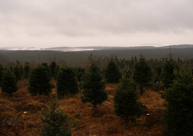
Apple orchards, blueberry fields, Christmas tree farms. The agricultural activities that a region is successful at very often become one of the iconic landscape images of that place. I could probably name a crop and you would be able to give me a state or province associated with it: Potatoes, corn, wheat? And yet, though these iconic agricultural landscapes may appear timeless, their continued existence is dependent on market forces. Nova Scotia’s Annapolis Valley is known for its apple orchards, but in the early 20th century, it had actually lost many of its orchards by the 1930s, cut down because they were no longer profitable. Historians have pointed out the irony that the tourism industry was making money off of Annapolis Valley orchards at a time when apple farmers were not.
I mention all this because I came across an article on the CBC today about market pressures currently facing our Christmas tree growers. The industry, according to the report, employees 4,000 people and generates $30 million a year. In my opinion, the Christmas tree industry is an attractive aspect of our agricultural landscape (in short: I love the landscape of a Nova Scotia Christmas tree farm) and serves an additional leisure/tourism function. Nevertheless, it is just as vulnerable to market forces as any other agricultural activity, in this case, vulnerable to the move towards massive bulk purchases of trees by big box stores.
The loss of orchards usually does not mean the loss of productive agriculture, or at least of arable land (unless they get sold off for housing). The loss of Christmas tree farms would be a little different; they are usually located on land unsuitable for food-growing. Maybe they would be left to return to forest were they to become economically unfeasible.
This blog is inactive but not defunct, and I wanted to test out the WordPress Android app to see if it might help me create or post content. The first image is of Lawrencetown Beach from MacDonald Hill. The second is of the bottom of Porters Lake and Lawrencetown Hill, with the ocean just beyond. Two of my favourite ‘home sights.’
It’s a shame, I still have all my Google Alerts set up for this blog, and every week when the alert shows up in my email, I look it over, click on the links that interest me, and then leave those web pages open, waiting, for weeks, until I finally close them in defeat, knowing I will never get around to sharing them. The time and thought that I feel is necessary to make even a simple post of links “worthwhile” has been holding me back. But not today! Two links, with almost no comment, that are related to the Nova Scotia landscape:
This one is about an urban planning association looking for the public to vote on the best public spaces in Canada. Nova Scotia has a few nominees. Here is the link to the cbc’s article, and the link to the competition website.
This is a link to an article about the architecture firm MacKay-Lyons Sweetapple, their recent awards, and the goals for one of the firm’s partners (Talbot Sweetapple). I like that it’s an interview with Sweetapple, since Brian McKay-Lyons is the higher profile partner. MacKay-Lyons formed his firm in 1985, and joined with Sweetapple in 2005. I may have talked about my appreciate for this firm’s Nova Scotia work before – they are celebrated for their modern designs that are built with a real appreciation of the surrounding landscape and sense of place.
So there you go! Finally, after all this time, I was able to get over myself just enough to share some links. If I can make a habit of it, we might be back in business.
*The image is a model of a MacKay-Lyons house that I built for a first-year landscape architecture class in 2009.
I have had this link in a Firefox window for at least a month; I reload it every time I shut my computer down and start it up again. So while I sit here at the airport waiting to fly home to Nova Scotia for Christmas, I may as well post it. The link is to a book review for In the Province of History: The Making of the Public Past in Twentieth Century Nova Scotia by Ian McKay and Robin Bates.
Frankly, I got so much Ian McKay exposure during my MA thesis that I haven’t been able to bring myself to borrow this book from the school library yet. Besides, based on the review, I’ve already seen firsthand most of the primary material the book draws from, and it doesn’t sound like McKay has really developed his previous work on the topic much further. That said, if you’d like to know what one of the few scholars who work(ed) in the field of Nova Scotia tourism history says about the subject, this review is an excellent summary. The reviewer, Dr. Paul W. Bennett, also raises some of the primary problems with McKay’s analysis, mainly McKay’s emphasis on Premier Angus L. Macdonald as being a primary instigator of the provincial mythos, as well as the idea that the tourism impulse resulted in a united sort of provincial image.
I was reading the Complete Works of poet Elizabeth Bishop last night, and was struck again with how perfect Bishop’s poem “Cape Breton” captures what I always thought construction season must have been like on the island during mid-century (and I thought about that quite a bit while I was writing my thesis). In the poem, the construction of the coastal road, abandoned on Sunday, serves to enhance the mystery of the interior. It’s all ocean and hill and mist and road and then a little bus rolls down the dusty road packed with people going about their Sunday business (including “today only two preachers extra, one carrying his frock coat on a
hanger”).
Wind Turbing in Pubnico, NS. Photo c. Andrew d'Entremont, used under Creative Commons license
One of the topics we addressed a few times over in my landscape architecture classes this year is the issue of our current landscape values and how new technologies may conflict with them. This was again brought to mind for me this week when I saw two news reports on the CBC – one announcing Nova Scotia’s latest commitment to renewable energy, and the other out of Lunenburg about the conflict between heritage planning values and energy conservation values.
A couple in Lunenburg want to put solar panels on their roof; this is against against Lunenburg’s heritage conservation bylaws, which are designed to preserve the town’s internationally recognized historical landscape. It’s a conflict that we might see a lot more of in the coming years, particularly if the province’s new energy initiative has tangible results. Do solar panels work against the integrity of heritage landscapes? Are wind turbines an ugly blight on our landscape, a utilitarian sight that is merely acceptable, or an icon of sustainability and therefore, potentially, attractive? And if our landscape and coastline is transformed by these new energy endeavours, how are we going to reconcile it to our own vision of what Nova Scotia’s landscape looks like, as well as with our current tourism approach?
I guess it was rather (okay, extremely) optimistic of me to assume that a Masters of Landscape Architecture degree would provide absolutely any time for composing thoughtful blog posts on the Nova Scotia landscape during term. So here I am on a Saturday night at the end of term, a school year away from my most recent post. I finally have time to think about a topic that still occupies an inordinately prominent place in my thoughts (just ask my fellow students – I can’t shut up about Nova Scotia).
If this job search continues very long, I may just have time to get in a few posts this summer. And it will be more useful for the homesickness than before, as it is looking more and more likely that I will be spending my time here in Ontario. Is there a set of lyrics to “Farewell to Nova Scotia” for Bluenosers who are landlocked?